Jökulhlaup
Glacier outburst floods
Glacier
lakes | Glacier dam | Mechanism
| Lake Russell | Grímsvötn
| Hydrographs | Figures |Questions
| References
|
What is a jökulhlaup:
Sudden and rapid draining of a glacier dammed lake or of water impounded
within a glacier
|
Effects:
- Flooding, fast and without much warning
- Loss of life
- Destruction of roads, railways etc.
|
|
What causes jökulhlaup:
- Glacier blocks a stream in a valley
- Geothermal melt collects beneath the glacier
- Moraine left by retreating glacier
|
How big are jökulhlaup:
- Grímsvötn, Iceland, 1934: Peak flow 5 *104
m3 s-1 (about 1000 times the normal Snohomish river discharge)
- Lake Missoula: 107 m3 s-1 estimated
|
Types of glacier-dammed lakes:
Moraine-dammed lakes
Ice retreats from a large terminal moraine, and a lake forms between the
moraine and glacier.
Examples: 1) Nostetuko Lake, BC. The Little Ice
Age moraine dammed a lake that drained catastrophically by cutting a channel
through the moraine in 1983. 2) Manang, Nepal. The town of Manang is
across the valley and above the moraine dammed lake.
Marginal lakes
Glacier blocks a normal drainage channel
Example: 1) Laguna Parron, Peru. A debris
covered glacier terminus forms the dam. The lake level has been lowered by
drilling a tunnel through the bedrock. 2) Lake Russell, Alaska.
Sub-glacial lakes
A geothermal area (possibly volcano) melts the glacier ice
Example: 1) Grímsvötn, Iceland.
|
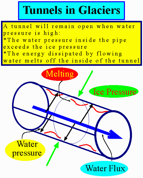
Glacier as a dam
When the ice is thick and the lake shallow, the glacier is a very good dam. The flow of ice can seal cracks, as long as the pressure from the overlying ice is much larger than that of the water trying to get out through the cracks.
If the lake is deep the glacier is not a good dam. Water can flow through glaciers in tunnels. If the pressure is close to or higher than the overburden pressure, there is nothing the tunnel can do to reduce the pressure. The tunnel then grows, since the flowing water also melts the inside of the tunnel.
Ice floats in water, so the water may actually lift up its dam
|
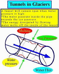 |
Mechanism for jökulhlaup
(Grímsvötn)
Initiation of flow
- Water level is still ~20 m below floatation, so floatation is not necessary.
- Excess pressure
 shear stress at 45 deg to vertical wall. If
shear stress larger than 100 kPa ( 200 m water level) then plastic flow of ice.
But jökulhlaup often happen at lower lake levels.
shear stress at 45 deg to vertical wall. If
shear stress larger than 100 kPa ( 200 m water level) then plastic flow of ice.
But jökulhlaup often happen at lower lake levels.
- Flow through tunnels, and melting out of tunnels.
Why the sudden end:
- Rock level, for the lake
- All the water drained
- Collapse of tunnels due to reduced pressure
|
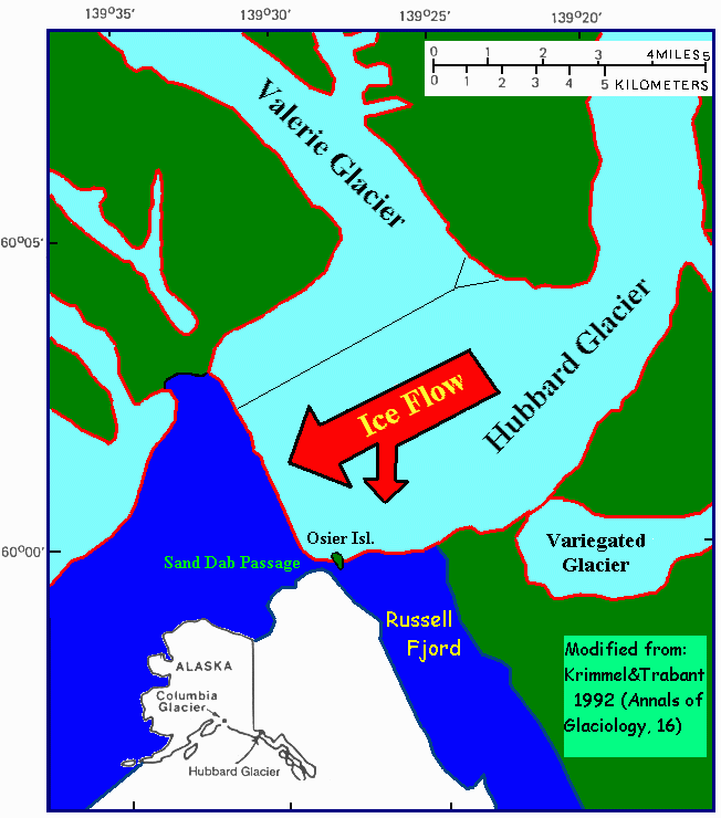
Lake Russell, Alaska
Hubbard glacier is a large glacier ending in the ocean near Yakutat, Alaska.
In May 1986 a surge of the Valerie glacier, a tributary of Hubbard glacier
caused Hubbard to advance across the entrance of Russell fjord, turning the
fjord into a lake. The lake rose to 25.5 m above sea level. On October 8, 1986,
the ice dam burst and Lake Russell drained in a few hours back down to sea
level. The peak flow was about 100,000 m3.
|

|
|
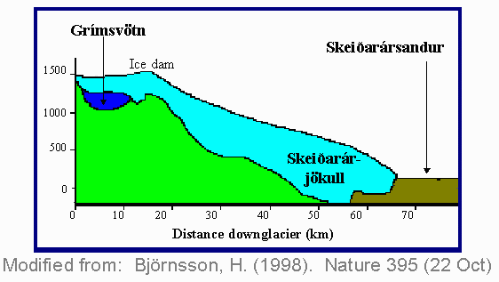
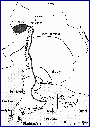
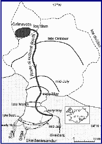
Grímsvötn
Geometry
- A geothermal area
melts ice from the base to form a lake which leads to a depression at the surface
which collects surface melt-water into the lake.
- The lake is almost completely covered with a 200 m thick ice shelf.
- Drains through a subglacial passage 50 km long.
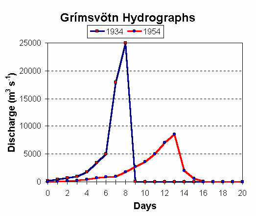
- Typical hydrographs:
Rise ~10 days, Fall ~2 days.
- Water level drops by ~60 m.
Typical numbers
- Peak flow: 600 - 40 000 m3 s-1
- Total volume: 0.5 - 4.0 km3
- Size of tunnel: 25 - 85 m radius (1996 flood)
- The 1996 flood: 3.2 km3 of water in 40 hrs
- Periodicity: 1 - 10 yrs
|

|
|
Hydrographs
Hydrographs are records of discharge in rivers over time.
Jökulhlaup hydrographs (figure) have an exponential rise and even more
rapid decay.
Stream flow hydrographs, rapid rise in response to rainfall, then tail
off slowly, due to the slow evacuation of ground water.
|
 |
Figures
|
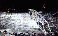
Jökulhlaup from Summit Lake at Ninemile, Alaska on 17 Sep. 1967. The discharge was nearly 3000
m3s-1, 100x the normal discharge. The bridge was washed away a few
hours later. (From: Benn and Evans,
1998. [Fig. 3.21, p.
117]) |
|
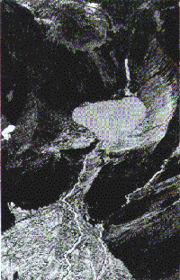
Moraine-dammed Nostetuko Lake in British Columbia,
Canada, which drained catastrophically in 1983 when the Little Ice Age
moraine was breached as a result of glacier avalanche from the Cumberland
Glacier in the distance.
(From: Benn and Evans, 1998. [Fig. 3.24, p.
119]) |
|
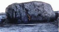
Skeiðarársandur 1997. After the
jökulhlaup in November 1996, these big icebergs were left all over
Skeiðarársandur. For scale, the girl in the picture probably is
reaching 2 m up.
(From: Þröstur Þorsteinsson, 1997.
[More pictures and description of the eruption and jökulhlaup can be
found at http://jokulhlaup.turdus.net]) |
Group
Questions
1. Hydrographs are the records of discharge in rivers over time.
The flux is calculated from the "stage" or height of a river in its banks.
(a) Suppose a watershed has no glaciers or lakes. When a rainstorm occurs in the watershed, water gets into the main channel in several
ways:
- rainfall directly into channels
- direct over-land flow into tributary streams and channels which then flow into the main channel
- seepage raising the groundwater table (storage), followed by slow seepage out into streams as the water table falls back over the course of hours or days.
What does a typical hydrograph on the main channel look like after a rainstorm
in this valley ?
* Does the river rise rapidly or slowly?
* Does it fall rapidly or slowly?
(b) Suppose a glacier dammed lake is about to fail. A glacier outburst flood starts with a very small leak from the lake as the dam approaches the flotation level.
What does a typical hydrograph on the main channel look like after an outburst
flood up the valley ?
* Does the river rise rapidly or slowly?
* Does it fall rapidly or slowly?
(c) As a Park Ranger in Denali Park, how might you tell if an outburst flood
is starting ?
2. Building up to a jökulhlaup.
Your group will describe the events leading to a jökulhlaup from a glacier-dammed river.
(a) Suppose the river is running freely out of the valley when a nearby
glacier surges.
What happens when the glacier blocks the river ?
* Behind the dam, in front of the dam
(b) When can we expect an outburst flood ?
* How much water (think about the height of the water column as a
fraction of ice thickness) has to accumulate ?
* If the water is 45 m deep, how thick is the ice dam ?
* How long would it take to fill the lake to this level ?
- Assume that you have dammed a reasonably big river with normal river flow of 45 m3/s (Snohomish ~47 m3/s-1)
- you can estimate the volume of water that is needed before a flood
will happen if you know that the lake covers an area 1 km wide and 10 km
long (~10^7 m^2)
- use 1 yr ~ 3*10^7 s
(c) How will the area where the river used to run be affected ?
* What is the river flow be like, what would happen to a salmon hatchery in ponds downstream ?
* Would the turbulent current be likely to deposit something ?
3. Initiation of jökulhlaup. Describe the final moments
of the ice dam.
(a) What happens when the water level reaches the critical height ?
* Think in terms of floatation, leakage, tunnels
(b) Why do the tunnels grow rapidly ?
* Is the pressure high or low ?
* Is the water moving slowly or quickly, what does that mean for melting ?
(c) Why the sudden end to the jökulhlaup ?
* Where is the water ?
* What happens to the tunnels ?
References
Baker, V. (1995). Surprise endings to catastrophism and controversy
on the Columbia. GSA Today, 15(9).
Björnsson, H. (1992). Jökulhlaups in Iceland:
predictions, characteristics and simulation. Annals of Glaciology,
16, 95 - 106.
Björnsson, H. (1998). Hydrological characteristics of the drainage
system beneath a surging glacier. Nature, 395, 771 -
774.
Krimmel, R. M. and D. C. Trabant (1992). The terminus of Hubbard
Glacier, Alaska. Annals of Glaciology, 16, 151 - 157.
Parfit, M. (1995). The floods that carved the West. Smithsonian,
26(1), 48 - 59.